Supporting humanitarian aid missions. Assessing the damage caused by a flood or an earthquake. Detecting the presence of military and paramilitary troops. Monitoring
national borders. Surveilling the coast for piracy, drug traffick- ing, human smuggling. Identifying chemical weapon storage sites. The EU’s Common Foreign and Security Policy relies on a ‘fresh pair of eyes’ watching over the Earth 24/7: the Satellite Centre (SatCen), located in Torrejón (Madrid), provides fast and reliable analysis of satellite data in order to face current security challenges. The High Representative / Vice President Josep Borrell visited the centre last February.
“On security-related matters, the European Union’s Satellite Centre [SATCEN] has helped to deliver key geostrategic intelligence analysis to the European Union and Member States, contributing to monitoring the crisis of conflict areas and sup- porting the EU advisory operations”, EU High Representative / Vice President Josep Borrell Borrell said at the 12th European Space Conference last January.

PROVIDING GEOSPATIAL INTELLIGENCE SINCE 1992
Founded in 1992 as a Western European Union body, SatCen was incorporated as an EU agency in 2002. The centre uses high-resolution satellite imagery to create various geospatial intelligence (GeoInt) products useful for different purposes. The basic principle of GeoInt is to organize and combine all available data around a geographical location on Earth and then exploit it in order to prepare products that can be easily used by planners, emergency responders and decision makers.
Although geospatial intelligence is normally associated with a military context, it is increasingly used by civilian and private sector organizations working in areas such as telecommunications, transportation, public health and safety, and real estate. Currently, SatCen supports the following activities:
HUMANITARIAN AID MISSIONS
GeoInt products based on satellite imagery interpretation are becoming more and more important in support of humanitarian assistance and disaster relief missions. EU SatCen is able to analyse refugee camps in order to provide information on the number of refugees, their provenance, and the existence of humanitarian or security facilities within camps, as well as on the presence of paramilitary activity and potential attacks on refugee camps. In the aftermath of a man-made or natural disaster, SatCen creates maps based on satellite data that are key to define priority areas for action, as well as safe areas and those that are still vulnerable to hazards.
CONTINGENCY PLANNING
In case of an emergency, SatCen’s products can contribute to preventing further casualties, reducing damage to infrastructures and resuming normal operations as soon as possible. Rapid mapping of affected areas, for instance, is key to manage emergencies and plan evacuation operations.
“When we are planning what to do in Libya, it immediately comes to our mind that we have a powerful tool observing what is happening there and guiding the operations on the ground” Josep Borrell.
GENERAL SECURITY SURVEILLANCE
SatCen provides EU decision-makers GeoInt products on a wide range of security issues such as border control, terrorism, piracy, illegal cropping or cross-border state disputes. The high resolution satellite imagery is often used to monitor illegal cross-border displacements, identify terrorist training camps or smuggling vessels, and back-up piracy operations. It also provides a non-intrusive means of treaty verification in cross-borders disputes where the EU acts as a mediator.
CRITICAL INFRASTRUCTURE
SatCen supports crisis management officials with the delivery of elements-at-risk maps where human settlements and critical infrastructure under threat are identified. They provide the basis for threat and vulnerability assessment studies that evaluate the likelihood of occurrence of identified threats to certain infrastructures (such as a dam, or a pipeline).
MILITARY CAPABILITIES
Analysing military activity and the deployment of ground, air and naval military forces is one of the main services offered by the EU SatCen. The centre also uses geospatial intelligence to conduct Battle damage assessments (BDA), an accurate estimation of the damage that results from the application of mil- itary force.
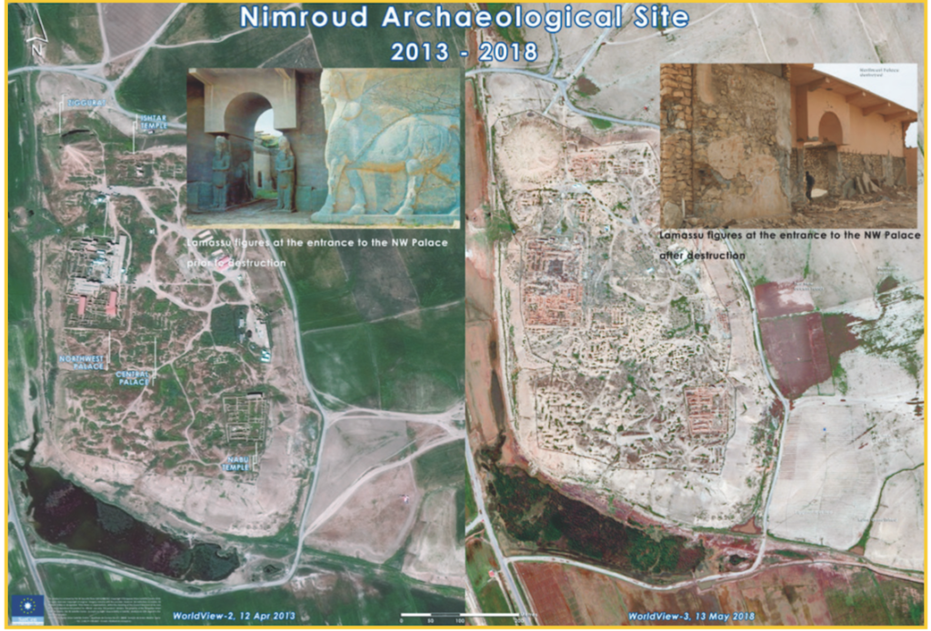
to February 2018 © SatCen
WEAPONS OF MASS DESTRUCTION
The SatCen non-proliferation mission follows the entire process of weapon development, from the detection of uranium mining activity to the assessment of a nation’s nuclear fuel fabrication infrastructure. Locations where weapons are suspected to be produced or stored are identified and monitored thanks to high-resolution satellite imagery.
The EU SatCen closely cooperates with other European schemes such as Copernicus (the EU’s Earth Observation Programme) and the Space Surveillance and Tracking (SST) Support Framework in developing new geospatial intelligence capabilities.
Click here to read the 2020 April edition of Europe Diplomatic Magazine