
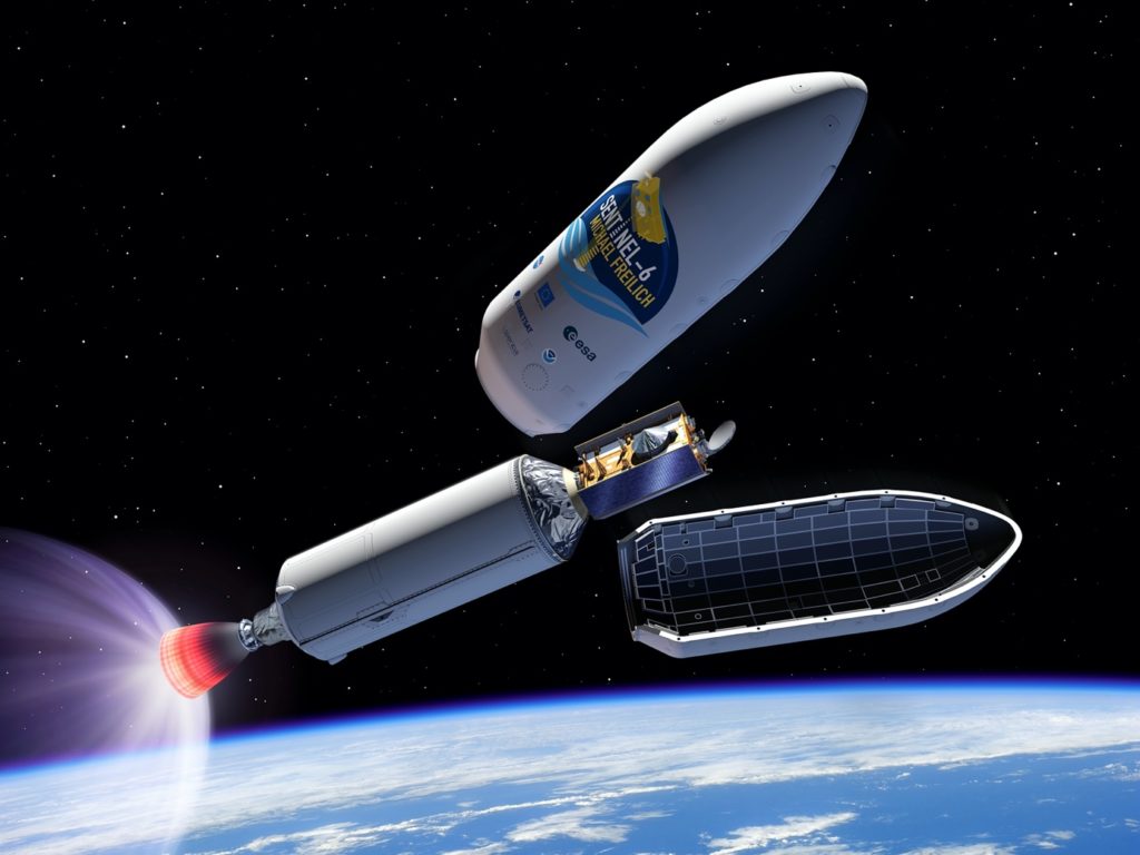
Copernicus Sentinel-6 lifts off
The Copernicus Sentinel-6 Michael Freilich satellite has been launched into orbit around Earth on a SpaceX Falcon 9 rocket.
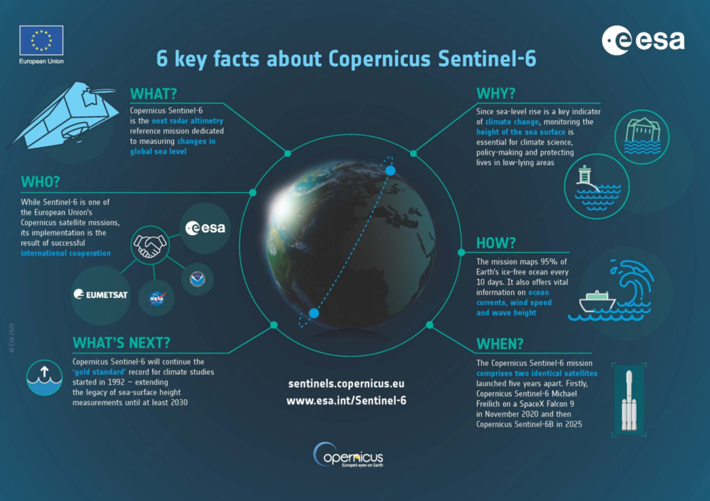
Using the latest radar altimetry technology, this new satellite is set to provide a new overview of ocean topography and advance the long-term record of sea-surface height measurements that began in 1992 – measurements that are essential for climate science, for policy-making and, ultimately, for protecting the lives of millions at risk of sea-level rise.
Carrying the 1.2 tonne Sentinel-6 satellite, the Falcon 9 rocket lifted off from the Vandenberg Air Force Base in California, US, at 17:17 GMT (18:17 CET, 09:17 PST) on 21 November. The satellite was delivered into orbit just under an hour after liftoff and contact was established at the ground station in Alaska at 19:49 CET.
ESA’s Director of Earth Observation Programmes, Josef Aschbacher, said, “I’m extremely proud to have seen Copernicus Sentinel-6 liftoff this evening and know that it’s well on its way to starting its mission of continuing the measurements of sea level that are so needed to understand and monitor the worrying trend of rising seas. I would not only like to thank the ESA teams that have worked so hard to get to this point, but also the EC, Eumetsat, NASA, NOAA and CNES, and, of course, we very much look forward to further fruitful cooperation between our respective organisations.”
With millions of people living in coastal communities around the world, rising seas are at the top of the list of major concerns linked to climate change. Monitoring sea-surface height is critical to understanding the changes taking place so that decision-makers have the evidence to implement appropriate policies to help curb climate change and for authorities to take action to protect vulnerable communities.
Over the last three decades, the French–US Topex-Poseidon and Jason mission series served as reference missions, and in combination with ESA’s earlier ERS and Envisat satellites, as well as today’s CryoSat and Copernicus Sentinel-3, they have shown how sea level has risen about 3.2 mm on average every year. More alarmingly, this rate of rise has been accelerating; over the last few years the average rate of rise has been 4.8 mm a year.
Now in orbit, Copernicus Sentinel-6 Michael Freilich will soon pick up the baton and extend this dataset – a dataset that is the ‘gold standard’ for climate studies. The mission comprises two identical satellites launched sequentially – so in five years, Copernicus Sentinel-6B will be launched to take over. The mission as a whole will ensure the continuity of data until at least 2030.

Each satellite carries a radar altimeter, which works by measuring the time it takes for radar pulses to travel to Earth’s surface and back again to the satellite. Combined with precise satellite location data, altimetry measurements yield the height of the sea surface.
The satellites’ instrument package also includes an advanced microwave radiometer that accounts for the amount of water vapour in atmosphere, which affects the speed of the altimeter’s radar pulses.
While heritage has been key to the mission’s design, Sentinel-6 brings, for the first time, synthetic aperture radar into the altimetry reference mission time series. To ensure that no bias is introduced into the time series, the radar instrument operates in a continuous burst mode, simultaneously providing conventional low-resolution mode measurements and the improved performance of synthetic aperture radar processing.

To ensure that the data time series is continuous despite the change of instrument technologies, Sentinel-6 Michael Freilich is spending its first year in orbit flying just 30 seconds behind Jason-3.
Orbiting at an altitude of over 1300 km and reaching 66°N and 66°S, Sentinel-6 provides sufficient measurements to map the height of the sea surface over 95% of the world’s ice-free oceans every 10 days.
While Sentinel-6 is one of the European Union’s family of Copernicus missions, its implementation is the result of a unique cooperation between the European Commission ESA, Eumetsat, NASA and NOAA, with contribution from the CNES French space agency.
The European Commission’s Director-General for Defence Industry and Space, Timo Pesonen, said, “We are very pleased to welcome this newcomer to the EU’s fleet of Copernicus Sentinel satellites. Copernicus Sentinel-6 Michael Freilich will enable delivering enhanced products and information concerning the oceans and the atmosphere to improve the daily lives of our citizens. The arrival of this satellite is another success for Copernicus, for Europe, for all mission partners and worldwide.”

ESA has been responsible for the development of the Poseidon-4 radar altimeter and development of the Copernicus Sentinel-6 Michael Freilich, as a whole. It is also responsible for the procurement of Copernicus Sentinel-6B on behalf of the European Commission and Eumetsat.
Transfer of ownership goes to the EC at the point of liftoff. ESA takes care of the early orbit phase of as well as in-orbit verification planning, and supports flight operations performed by Eumetsat.
Eumetsat is responsible for the development of the ground segment and for operations after the launch and early orbit phases. Eumetsat processes the data and delivers the data products services to European users.
Eumetsat’s Director General, Alain Ratier, said, “Data from Copernicus Sentinel-6 Michael Freilich will be the most accurate yet and will be used to gain a deeper understanding of global sea-level rise, a key indicator of climate change. The data will also be used for weather forecasting, from improving the accuracy of seasonal forecasts to predicting the tracks of hurricanes and cyclones.”

NASA has the responsibility for the launch services, the development of the microwave radiometer, the laser retroreflector and GNSS radio occultation receiver. It also provides ground segment support and contributes to the operations and data processing in the US. NASA and NOAA share responsibility for the distribution of data products to users in the US.
“Mike Freilich helped ensure NASA was a steadfast partner with scientists and space agencies worldwide, and his love of oceanography and Earth science helped us improve the understanding of our beautiful planet,” said Thomas Zurbuchen, NASA’s Associate Administrator for Science at the Agency’s Headquarters in Washington. “This satellite, so graciously named for him by our European partners, will carry out the critical work Mike so believed in – adding to a legacy of crucial data about our oceans and paying it forward for the benefit of future generations.”
Source: ESA
