
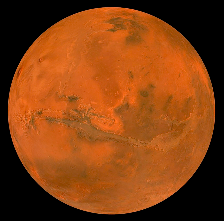
Simulated view of the HRSC colour mosaic from 2500 kilometres above the Valles Marineris rift valley, aligned along the Martian equator and with locally enhanced colour : a composite of red and blue filter mosaics, with the colour bands stretched individually © ESA/DLR/FU Berlin (G. Michael)
- The Mars Express mission, Europe’s first interplanetary mission, and all of its experiments continue to function almost perfectly after 20 years of scientific operations.
- The High Resolution Stereo Camera (HRSC) camera, built by DLR in collaboration with German industry, has mapped almost the entire surface of Mars in colour and three dimensions at an image resolution of 20 metres per pixel since 2004 and is unprecedented.
Exactly 20 years ago, on 2 June 2003, the Mars Express spacecraft, the first European mission to explore another planet in the Solar System, launched on a Soyuz launch vehicle from the Baikonur Cosmodrome in Kazakhstan. A Fregat upper stage delivered the mission on a transfer orbit to Mars, which the spacecraft reached on 25 December of the same year. The High Resolution Stereo Camera (HRSC), developed at the German Aerospace Center (Deutsches Zentrum für Luft- und Raumfahrt; DLR) and operated by the DLR Institute of Planetary Research, is one of seven experiments on board. The mission was originally only supposed to last one martian year (approximately two Earth years), but the success of the instruments, which continue to work flawlessly, has prompted the European Space Agency (ESA) to extend the mission again and again, most recently until the end of 2026. On 19 October 2023, Mars Express will have orbited Mars 25,000 times in its elliptical orbit. To mark the 20th anniversary of the launch, a celebration will take place today, 2 June, at ESA’s European Space Operations Centre (ESOC) in Darmstadt at the end of a scientific and technical symposium.
To acquire its usual surface images, the HRSC normally photographs Mars from an altitude of approximately 300 kilometres, at roughly the point in its elliptical orbit at which the Mars Express spacecraft is closest to the planet. The resulting views of the martian surface have a spatial resolution of up to 12.5 meters per pixel and cover areas approximately 50 kilometres wide. Thanks to its four colour channels (red, green, blue, infrared) and five panchromatic nadir, stereo and photometric channels, the stereo camera can visualise Mars in three dimensions and also in colour.
For the global data product presented here, however, 90 individual images were used, taken from higher altitudes (between roughly 4000 and 10,000 kilometres) above the martian surface and thus covering areas approximately 2500 kilometres wide on average and at lower spatial resolution (between 200 and 800 metres per pixel). Such large-scale images are typically acquired to observe weather patterns on Mars. But if no clouds or other atmospheric phenomena are visible on the images, they are excellent for creating global views of the martian surface.
| A more diverse colour view
The ever-changing transparency of the martian atmosphere makes it difficult to determine accurate surface colours from orbit. The scattering and reflection of light off of atmospheric dust causes colour shifts between images. As a result, a mosaic that combines many such images may suffer from a patchwork of colours. Until now, suppressing this effect through image processing has had the consequence of diminishing colour variations over greater distances. Here, a new high-altitude observation campaign was used to construct a global colour model, which was then used to colour-reference each image of the mosaic, enabling long range colour variations to be maintained and revealing a more diverse colour view of the planet than has ever been seen before.
| Each colour a different material
The global view of Mars shown here has a spatial resolution of two kilometres per pixel, although higher resolution global HRSC mosaics are possible and are already in development. Since its commissioning in January 2004, the HRSC has imaged almost the entire planet – an area of almost 150 million square kilometres – at image resolutions of between 50 and 20 metres per pixel. Many areas have been imaged at the instrument’s highest possible resolution of 12.5 metres per pixel. This contrast-enhanced mosaic (image 1), with a resolution one hundredth of this maximum, reveals an unprecedented variety and detail of colours across the martian surface, which also provide information about its composition.
It is well known that most of Mars is reddish in colour, due to the high amount of oxidised iron in the dust on its surface, earning it the nickname the ‘Red Planet’. But it is also immediately noticeable that a considerable region of Mars is rather dark, appearing bluish in colour in image 1. These regions represent greyish-blackish-bluish sands, which are volcanic in origin and form large, dark sand layers on Mars. They were primarily piled up by the wind to form imposing sand dunes or enormous dune fields on the floor of impact craters. These unweathered sands consist of dark, basaltic minerals, of which volcanic lava on Earth is also composed. Basalt is the most widespread volcanic rock on Earth – and in the Solar System. Earth’s ocean floor is made of basalt, as are the extinct volcanoes of the Eifel, Mount Etna in Sicily and volcanoes of the Hawaiian archipelago.
Volcanic material on Mars that has been weathered by water, on the other hand, tends to take on lighter shades over time. For example, clay and sulphate minerals – the two most common minerals on Mars formed through the contact of cooled lava and water – appear particularly bright on such colour composites and are relatively easy to recognise on closer inspection. One of the largest clay mineral deposits on Mars, located around the former outflow channel Mawrth Vallis, is not shown in this view but was also previously imaged using the HRSC. It attests to the former long-term presence of water on Mars, with the original, basaltic source rock having weathered to clay minerals at neutral pH and relatively warm temperatures.
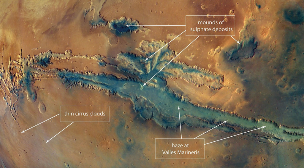
Large deposits of similarly light-coloured sulphate minerals such as gypsum (calcium sulphate) or kieserite (magnesium sulphate) can be seen in this mosaic within the Valles Marineris canyon system – a vast rift valley over 4000 kilometres long and stretching along the martian equator. Here, they are covered by a thin veneer of dark sand and thus only reveal their impressive colour variations on closer inspection made using the HRSC. Sulphate minerals indicate environmental conditions at low, acidic pH values, which are less accommodating to life.
The faint, bright and light blue areas depict clouds in the atmosphere. Images containing clouds could not be entirely avoided in the creation of this first version of the global Mars mosaic. The depths of Valles Marineris are also overlaid with atmospheric phenomena. However, these represent fog and haze), which often form within depressions at certain times of the day and year.
The development of the colour model method and processing of the mosaic was performed by Greg Michael, who is part of the HRSC team at Freie Universität Berlin. The planning and acquisition of the high-altitude images were the responsibility of the camera operations team at the German Aerospace Center (DLR) at Berlin-Adlershof.
